Article
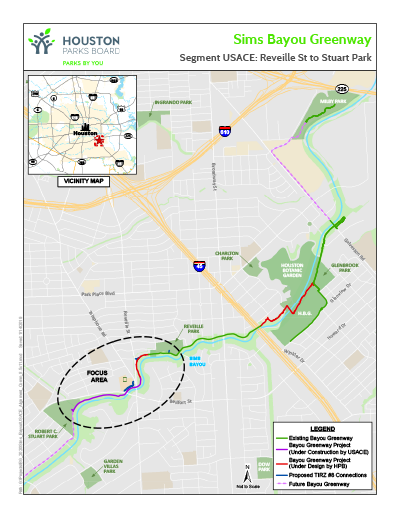
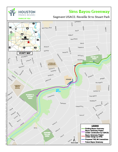
The USACE is beginning construction on a new 0.65-mile segment of Sims Bayou Greenway
This new segment will start on the east side of Reveille Street and extend west to Stuart Park along the north side of the bayou.
Notable features of this new greenway include:
- New 10-foot-wide concrete trail along Sims Bayou.
- A connection into Robert C. Stuart Park, a 27-acre nature park that the Houston Parks Board acquired from the Stuart Family and transferred to the City of Houston Parks and Recreation Department.
- Ongoing maintenance of the greenway by the Houston Parks Board including weekly trash pickup, bi-weekly mowing, upkeep of the trail and amenities, and flood cleanup of the trail upon completion of construction by the United States Army Corps of Engineers (USACE).
The full length of this 0.65-mile segment of Bayou Greenway is estimated to be complete in the summer of 2019. Residents should be mindful of the active construction site along the bayou, where construction vehicles will be entering and exiting. Residents/the public should not enter areas surrounded by orange construction fencing.
In addition to the USACE’s project, the Houston Parks Board is designing a new 0.29-mile trail to continue east of Reveille Street to the existing trail at Reveille Park. Design is currently underway and estimated to be built in 2020.
After completion of these stretches of greenway, the Houston Parks Board will look for opportunities to install directional and educational signage, trash cans and recycling bins, and benches, and plant wildflowers.
The Houston Parks Board is also working closely with the Gulfgate TIRZ #8 (Tax Increment Reinvestment Zone) to create additional trail connections into the community. The connections, funded by Gulfgate TIRZ #8, will connect people into Reveille Park, to the east side of Reveille Street, and to the shopping center on the west side of Telephone Road. Lighting under the Reveille Street/Telephone Road Bridges and the Bellfort Avenue Bridge will be included. The Hobby Area Management District will provide ongoing electricity and maintenance of the lights.
Please see the attached overall map and focus area map to see greenway routes and connections.
Sims Bayou Greenway is part of a citywide project called Bayou Greenways 2020, which is being led by the Houston Parks Board in partnership with the City of Houston and in close cooperation with the Harris County Flood Control District. Bayou Greenways 2020 will create a continuous park system along Houston’s major waterways, transform more than 3,000 underutilized acres along the bayous into linear parks and connect 150 miles of hike-and-bike trails.
Want to know more?
Visit Sims Bayou Greenway webpage, which contains maps and project updates.